Access Management
Controlling where cars can enter and exit roads to reduce conflicts and make traffic flow more smoothly.
 Clarkston Safe Streets and Roads for All
Click the Citywide Recommendations and North Indian Creek/Montreal Road tabs below. You will find information and exercises that focus on draft recommendations for both the overall City of Clarkston and the North Indian Creek Drive/Montreal Road Corridor specifically:
Please take time to review the information under both tabs and offer your feedback as a part of this Online Survey. We appreciate you supporting this important project!
Controlling where cars can enter and exit roads to reduce conflicts and make traffic flow more smoothly.
Parts of the sidewalk which extend into a crossing, allowing drivers to see pedestrians more easily and shortening crossing distances
An entire intersection raised to the height of the sidewalk, allowing drivers to see pedestrians more easily and forcing vehicles to slow down
A paved path alongside the road where people can walk safely, separate from cars
Bike lanes with extra painted space, and possibly a physical barrier, between bicyclists and cars, providing more room and comfort for bicyclists
Bright green markings painted on the road to clearly show where bike paths are, helping drivers notice cyclists
A pedestrian-activated light designed to alert drivers or to stop traffic for pedestrians in crosswalks
Traffic signals with reflective borders, allowing them to be seen more easily
Roadway features that realign travel lanes in a staggered pattern, slowing traffic without restricting access
A raised island in the middle of a wide road where pedestrians can stop and wait before continuing to cross
Redesigning a road to have fewer or narrower car lanes, making room for bike lanes, sidewalks, parking, or turn lanes, which slows traffic and makes crossing easier
A set of safety improvements at an intersection, likely to include improving visibility and reducing speeds
More complex safety improvements specific to a single location See recommendation text for further detail
Lights specifically placed to brighten sidewalks and crossing, helping both pedestrians and drivers see each other at night
A circular intersection that guides traffic around a center island, limiting how and where vehicles interact with each other
Signs that alert drivers to upcoming hazards, like curves, pedestrian crossings, or changing road conditions
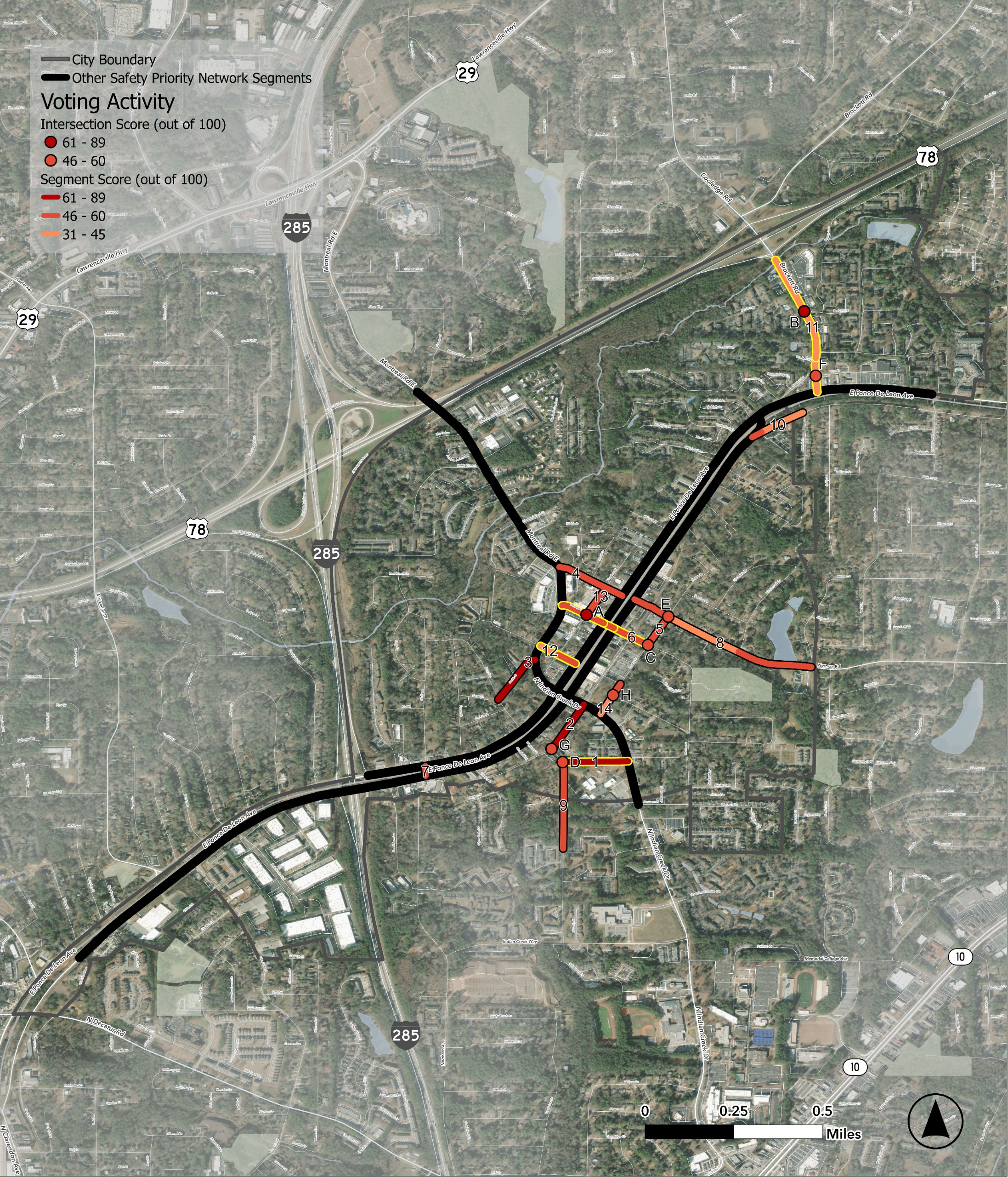
Across Clarkston, several locations have been identified as high priority for locations for safety improvements. Identified road segments are associated with a number on the map below (between 1 - 14) and identified intersections are associated with a letter (between A - H).
Five road segments/intersections currently have recommendations for specific projects. Those 5 locations are shown on the map with blue circles (from north to south):
After clicking on each circle and reviewing the location's suggested improvements, please respond to the questions below about each site.
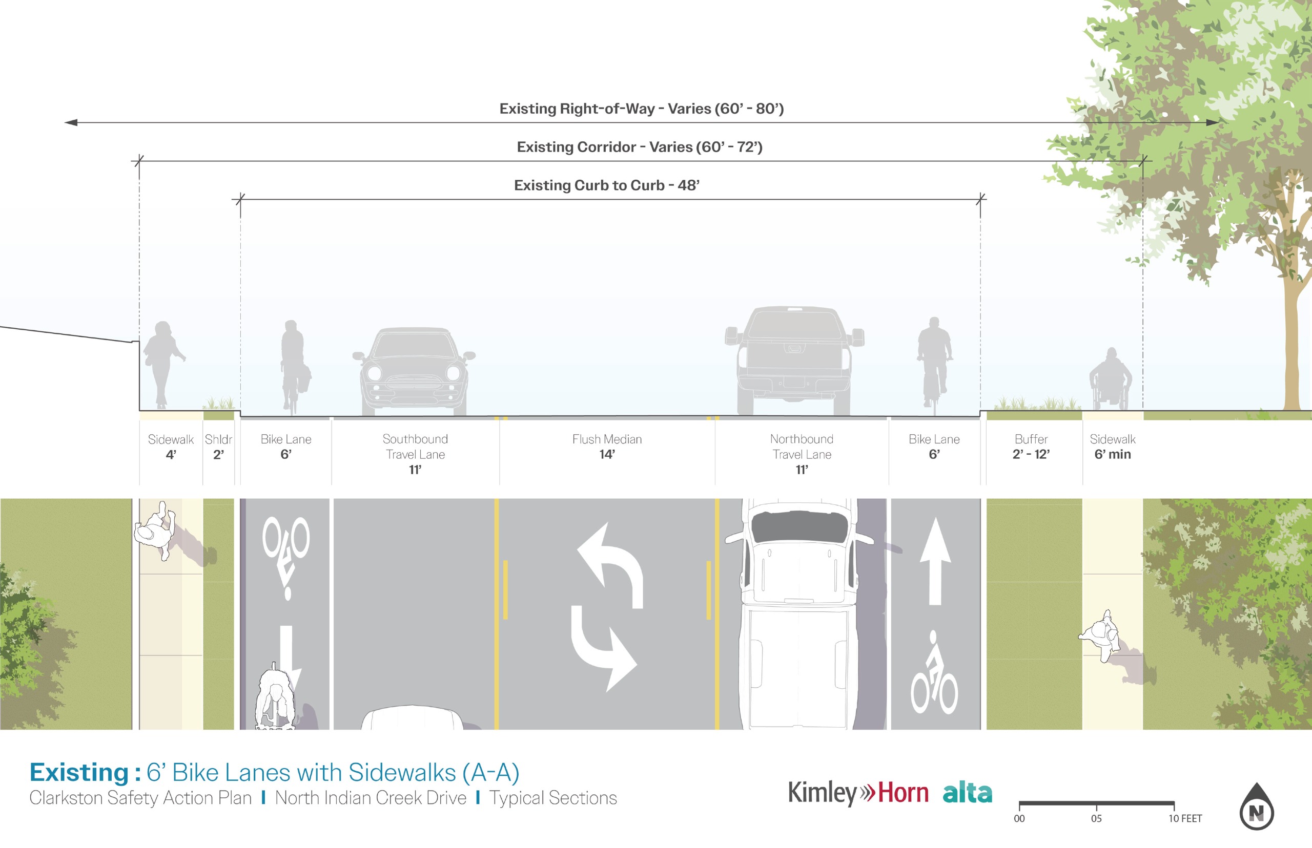
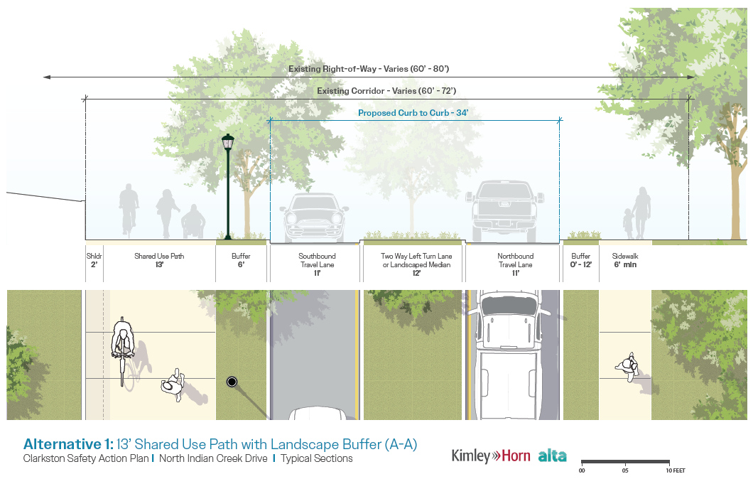
These sets of images depict typical, current corridor conditions on North Indian Creek Drive between Montreal Drive and the City of Tucker's boundary, though not representative of the entire corridor, as well as the preferred alternative for the corridor's design. After using the arrows on the slider to review both the existing conditions and preferred alternatives, please provide feedback below on the alternative.
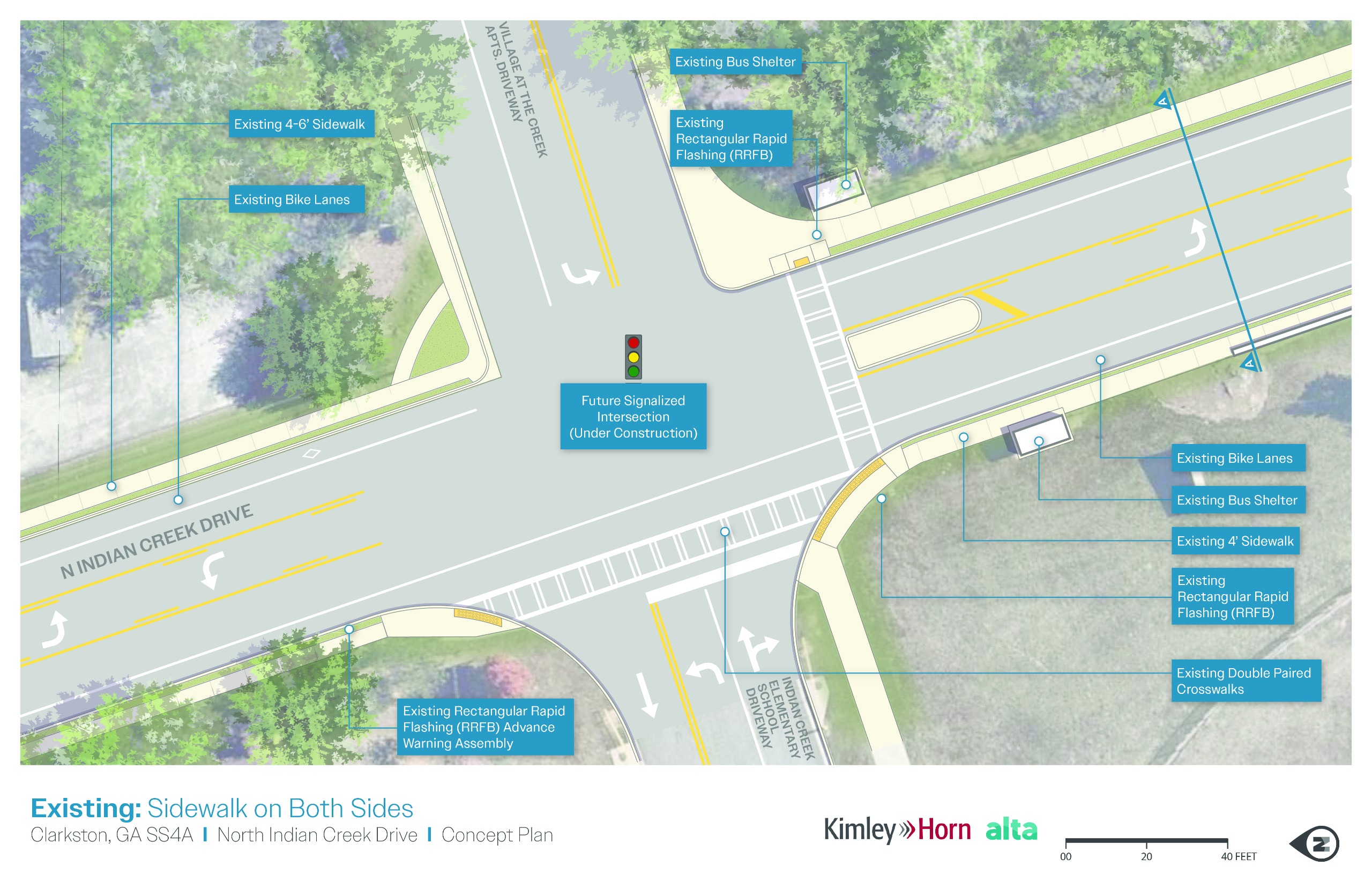
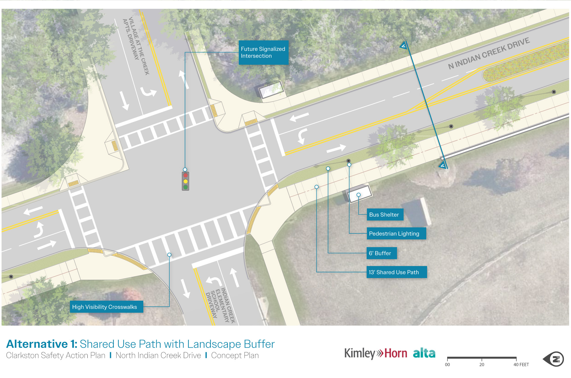
Along the Montreal Road/North Indian Creek Drive corridor, 6 locations were identified as places where specific safety improvements were most needed. The following 6 locations are shown on the map with red circles (from north to south):
Click on each circle and use the arrows to scroll through photos and information about each location, including existing conditions at the site and suggested improvement. After reviewing the photos and information, please respond to the questions below about each site.
Safe transportation systems protect lives, prevent injuries, and ensure that all road users—whether drivers, pedestrians, cyclists, or transit riders—can travel without fear of harm. Safe streets are a fundamental part of building inclusive, thriving, and connected communities where people of all ages and abilities can move freely and confidently.
The City of Clarkston Safe Streets and Roads for All Safety Action Plan is a proactive effort to make roadways safer and reduce traffic-related fatalities and serious injuries throughout the city. This plan follows national safety goals set by the U.S. Department of Transportation's National Roadway Safety Strategy and Vision Zero initiatives, which strive for zero traffic deaths and serious injuries for all road users. The Safety Action Plan combines data analysis, technical research, and input from stakeholders and the public to identify key safety challenges. The plan will recommend actionable strategies and projects to improve road safety and ensure safe travel for Clarkston's drivers, cyclists, pedestrians, and transit users.
Stakeholder and public participation play a crucial role in the development of the Safety Action Plan. Outreach efforts will educate Clarkston's residents and stakeholders on roadway safety trends and issues, and gather input on roadway safety perceptions, needs, and priorities that can be incorporated into the plan. Outreach techniques are designed to reflect Clarkston's community and encourage broad participation. Outreach is intended to generate meaningful feedback and build relationships that will support action once the plan is completed.
Please be sure to check this engagement site often to see how you can stay involved in the process.
In any transportation safety planning study, the vision, goals, and objectives are essential for providing direction and focus to the planning effort. They also help us to measure progress as plans turn into actions. Each plays a distinct but connected role in shaping a clear and actionable plan.
Clarkston will be a safe, welcoming, and walkable city where streets and public spaces prioritize people, foster belonging and community connection, encourage civic engagement, and provide the foundation for health, opportunity, and economic mobility for all who call Clarkston home.
Objectives:
Objectives:
Objectives:
Objectives:
Objectives:
Join us for a joint open house for the Clarkston Safety Action Plan and Phase 1 of the Clarkston Greenway! Both project teams are excited to share our progress and to hear your feedback on these efforts to make it easier and safer to get around. Details are as follows:
Help shape the future of transportation safety and accessibility in your community - join us at the Community Center on May 6!
Lead Planning Firm
Public Outreach
ChaQuias Miller-Thornton
City Manager
City of Clarkston
Larry Kaiser
City Engineer
City of Clarkston
Cristina Pastore, P.E., AICP
Project Manager
Kimley-Horn
Ed Caddell, AICP
Community Outreach Lead
Sycamore Consulting, Inc.